Practical Work in Geography Class 12 Solutions Chapter 6 Spatial Information Technology
Class 12 Practical Work in Geography Chapter 6 NCERT Textbook Questions Solved
1. Choose the right answer from the four alternatives given below
Question 1(i).
The spatial data are characterised by the following forms of appearance:
(a) Positional
(b) Linear
(c) Areal
(d) All the above forms.
Answer:
(b) Linear
Question 1(ii).
Which one of the following operations requires analysis module software?
(a) Data storage
(b) Data display
(c) Data output
(d) Buffering
Answer:
(d) Buffering
Question 1(iii).
Which one of the following is disadvantage of Raster data format?
(a) Simple data structure.
(b) Easy and efficient overlaying.
(c) Compatible with remote sensing imagery.
(d) Difficult network analysis.
Answer:
(d) Difficult network analysis.
Question 1(iv).
Which one of the following is an advantage of Vector data format?
(a) Complex data structure.
(b) Difficult overlay operations.
(c) Lack of compatibility with remote sensing data.
(d) Compact data structure
Answer:
(d) Compact data structure
Question 1(v).
Urban change detection is effectively undertaken in GIS core using:
(a) Overlay operations
(b) Proximity analysis
(c) Network analysis
(d) Buffering
Answer:
(b) Proximity analysis
2. Answer the following questions in about 30 words:
Question 2(i).
Differentiate between raster and vector data models.
Answer:
Raster data represents a graphic feature as a pattern of grids of squares, whereas vector data represents the object as a set of lines drawn between specific points.
Question 2(ii).
What is an overlay analysis?
Answer:
Overlay Analysis Operations is the hallmark of GIS. An integration of multiple layers of maps using overlay operations is an important analysis function. In other words, GIS makes it possible to overlay two or more thematic layers of maps of the same area to obtain a new map layer similar to the sieve mapping, i.e. the overlaying of tracing of maps on a light table to make comparisons and obtain an output map.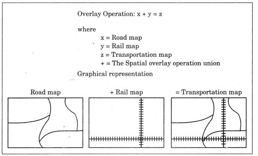
Question 2(iii).
What are the advantages of GIS over manual methods?
Answer:
GIS possesses inherent advantages of separate data storage and presentation.
It also provides options for viewing and presenting the data in several ways.
The important advantages of GIS are given below:
- Users can interrogate displayed spatial features and retrieve associated attribute information for analysis.
- Maps can be drawn by querying or analysing attribute data.
- Spatial operations (Polygon overlay or Buffering) can be applied on integrated database to generate new sets of information.
- Different items of attribute data can be associated with one another through shared location code.
Question 2(iv).
What are important components of GIS?
Answer:
The important components of a Geographical Information System include the
following:
- Hardware
- Software
- Data
- People
- Process
The different components of GIS are shown in figure given below: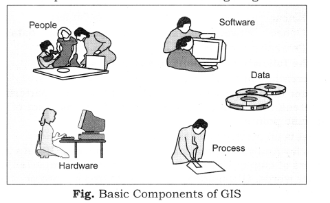
Question 2(v).
What are different ways in which spatial data is built in GIS core?
Answer:
Spatial Data Input is the spatial database into a GIS. It can be created from a variety of sources. These could be summarised into the following two categories:
- Acquiring digital data sets from Data Suppliers: The present day data supplies make the digital data readily available, which range from small- scale maps to the large-scale plans. For many local governments and private organisations, such data form an essential source and keep such groups of users free from overheads of digitising or collecting their own data.
- Creating digital data sets by manual input: The manual input of data to a GIS involves four main stages.
- Entering the spatial data.
- Entering the attribute data.
- Spatial and attribute data verification and editing.
- Where necessary, linking the spatial to the attribute data.
Question 2(vi).
What is Spatial Information Technology?
Answer:
It refers to the features arid the phenomena distributed over a geographically definable space, thus, having physically measurable dimensions. In other words, the Spatial Information Technology relates to the use of the technological inputs in collecting, storing, retrieving, displaying, manipulating, managing and analysing the spatial information.
3. Answer the following questions in about 125 words:
Question
3(i).
Differentiate between raster and vector data formats. Give example.
Answer:
|
Basis |
Raster Data Format |
Vector Data Format |
|
Meaning |
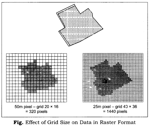
Raster data format represents a graphic feature as a pattern
of grids of squares. |
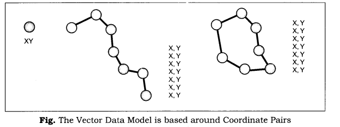
Vector data represents the object as a set of lines drawn
between specific points. |
|
Suitability |
The Raster file formats are most often used for the following
activities: |
The Vector files are most often used for: |
|
Advantages |
• Simple data structure |
• Compact data structure |
|
Disadvantages |
• Inefficient use of computer storage |
• Complex data structure |
Question 3(ii).
Write an explanatory account of the sequence of activities involved in GIS related work.
Answer:
The following sequence of the activities are involved in GIS related work—
1. Spatial data input: Under this data that are collected from different people are tested and it is checked whether they are as per suitability of investigator or not.
2. Entering of the attribute data: Attribute data define the properties of a spatial entity that need to be handled in the GIS, but which are not spatial. For example, a road may be captured as a set of contiguous pixels or as a line entity and represented in the spatial part of the GIS by a certain colour, symbol or data location.
3. Data verification and editing: The spatial data captured into a GIS require verification for the error identification and corrections so as to ensure the data accuracy. The errors caused during digitisation may include data omissions, and under/over shoots. The best way to check for errors in the spatial data is to produce a computer plot or print of the data, preferably on translucent sheet, at the same scale as the original. The two maps may then be placed over each other on a light table and compared visually, working systematically from left to right and top to bottom of the map. Missing data and locational errors should be clearly marked on the printout.
4. Spatial and attribute data linkages: The linkages of spatial and the attribute data are important in GIS. It must, therefore, carefully be undertaken. Linking of attribute data with a non-related spatial data shall lead to chaos in ultimate data analysis. Similarly, matching of one data layer with another is also significant.
5. Spatial analysis: The objective of geographic analysis is to transform data into useful information to satisfy the requirements of the decision-makers. It requires step-by-step procedures to arrive at the conclusion. The following spatial analysis operation may be undertaken using GIS:
- Overlay analysis
- Buffer analysis
- Network analysis
- Digital terrain model
Class 12 Practical Work in Geography Chapter 6 NCERT Extra Questions
Class 12 Practical Work in Geography Chapter 6 Very Short Answer Type Questions
Question 1.
What do you mean by Database Management System (DBMS) and the Computer-Assisted Cartography?
Answer:
The disciplines that deal with the principles and methods of data processing and mapping using a combination of computer hardware and the application software are termed as the Database Management System (DBMS) and the Computer-Assisted Cartography respectively.
Question 2.
What is Spatial Information System?
In order to understand geographical issues and many other questions, we need to capture the necessary data collected from different sources and integrate them using a computer that is supported by geo-processing tools. It is called Spatial Information System.
Question 3.
What do you mean by Spatial Information Technology?
Answer:
It refers to the features and the phenomena distributed over a geographically definable space, thus, having physically measurable dimensions. In other words, the Spatial Information Technology relates to the use of the technological inputs in collecting, storing, retrieving, displaying, manipulating, managing and analyzing the spatial information.
Question 4.
What do you mean by GIS?
It is defined as a system for capturing, storing, checking, integrating, manipulating, analyzing and displaying data, which are spatially referenced to the Earth. A system capable of all such functions is called Geographic Information System (GIS) This is normally considered to involve a spatially referenced computer database and appropriate applications software.
Question 5.
What are the different elements used to present data?
All data are characterised by:
- Definite Scale: It provides relationship between the map and the surface it represents.
- Use of Symbols: Symbols and colours which define attributes of entities mapped, (c) An agreed coordinate system, which defines the location of entities on the Earth’s surface.
Question 6.
What are different methods of presenting spatial data?
Answer:
The spatial data are represented in raster and vector data formats. Raster data represent a graphic feature as a pattern of grids of squares, whereas vector data represent the object as a set of lines drawn between specific points.
Class 12 Practical Work in Geography Chapter 6 Short Answer Type Questions
Question 1.
Name the disciplines associated with and helpful in Geographical Information System.
Answer:
It is an amalgamation of Computer Assisted Cartography and Database Management System and draws conceptual and methodological strength from both spatial and allied sciences such as Computer Science, Statistics, Cartography, Remote Sensing, Database Technology, Geography, Geology, Hydrology, Agriculture, Resource Management, Environmental Science, and Public Administration.
Question 2.
Differentiate between Spatial and Non-spatial data.
Answer:
The spatial data are characterised by their positional, linear and areal, forms of appearances. The data describing the information about spatial data are called as non-spatial or attribute data. In other words, you will be defining the attributes of the spatial data. Thus, non-spatial data are also known as attribute-data.
Spatial Data | Non-spatial Data Stock register of Geography Department | |||||
| S.No. | Names of the states | Total Literacy Rate | Male Literacy | Female Literacy | Description | Number |
| 1. | Kerala | 90.86 | 94.24 | 87.72 | Physical Map: India | 10 |
| 2. | Mizoram | 88.80 | 90.72 | 86.75 | Physical Map: World | 8 |
| 3. | Goa | 82.01 | 88.42 | 75.57 | Thermometer | 4 |
| 4. | Maharashtra | 77.27 | 85.97 | 67.51 | Barometer | 3 |
| 5. | Himachal Pradesh | 77.13 | 85.69 | 68.08 | Tracing Table | 2 |
| 6. | Tripura | 73.66 | 84.37 | 65.41 | Globe | 2 |
Question 3.
Explain the role of computer in Cartography.
Answer:
Computers play an important role in cartography.
- They help to draw maps and graphs speedily.
- They need a computer operator ad not a map expert.
- Maps drawn using computer are flawless.
- They save time as well as money.
- One can get its copies immediately.
- They can be presented well like different colours can be used for different groups.
Class 12 Practical Work in Geography Chapter 6 Long Answer Type Questions
Question 1.
Explain advantages and disadvantages of raster method.
Answer:
Advantages:
- It has simple data structure.
- It has easy and efficient overlaying.
- It is compatible with satellite imagery.
- High spatial variability is efficiently represented.
- It is simple for own programming.
- It uses same grid cells for several attributes.
Disadvantages:
- Inefficient use of computer storage is possible.
- Errors in perimeter and shape is possible.
- Difficult network analysis makes it cumbersome.
- Inefficient projection transformations are misleading.
- Loss of information takes place when using large cells, less accurate (although interactive) maps.
Question 2.
Explain the merits and demerits of vector system.
Answer:
Merits:
- Compact data structure.
- Efficient for network analysis.
- Efficient projection transformation.
- Accurate map output.
Demerits:
- Complex data structure.
- Difficult overlay operations.
- High spatial variability is inefficiently represented.
- Not compatible with satellite imagery.
Class 12 Practical Work in Geography Chapter 6 Viva Questions
Question 1.
Give full form of the following:
(a) DBMS
(b) GPS
(c) GIS
Answer:
(a) Database Management System
(b) Global Positioning System (GPS)
(c) Geographical Information System (GIS)
Question 2.
What are Raster data format?
Answer:
Raster data format represents a graphic feature as a pattern of grids of squares.
Question 3.
What are Vector data format?
Answer:
Vector data format represents the object as a set of lines drawn between specific points.
Question 4.
Name the process in GIS that helps in studying the changes in land use.
Answer:
Overlay.
Question 5.
What do you know about GIS?
Answer:
It is a system of capturing, storing, checking, integrating, manipulating, analysing and displaying data, which are spatially referenced to the Earth. It is normally considered to involve a spatially referenced computer database and appropriate applications software.
Question 6.
Name different components of GIS.
Answer:
- Hardware
- Software
- Data
- People
- Process
Spatial Information Technology Notes
- Computers enhance our capabilities in data processing and in drawing graphs, diagrams and maps.
- The disciplines that deal with the principles and methods of data processing and mapping using a combination of computer hardware and the application software are termed as the Database Management System (DBMS) and the Computer- Assisted Cartography respectively.
- Spatial Information System: In order to understand geographical issues and many other questions, we need to capture the necessary data collected from different sources and integrate them using a computer that is supported by geo-processing tools. It is called Spatial Information System.
- Spatial Information Technology: It refers to the features and the phenomena distributed over a geographically definable space, thus, having physically measurable dimensions. In other words, the Spatial Information Technology relates to the use of the technological inputs in collecting, storing, retrieving, displaying, manipulating, managing and.analysing the spatial information.
- Under Spatial Information Technology four systems work in a combined fashion. These are:
- Remote Sensing
- Global Positioning System (GPS)
- Geographical Information System (GIS)
- Digital Cartography, and Database Management Systems.
- Geographical Information System: It is defined as a system for capturing, storing, checking, integrating, manipulating, analysing and displaying data, which are spatially referenced to the Earth. A system capable of all such functions is called Geographic Information System (GIS). This is normally considered to involve a spatially referenced computer database and appropriate applications software.
- The advanced computing systems available since mid-1970s, enable the processing of georeferenced information for the purpose of organising spatial and attribute data and their integration; locating specific information in individual files and executing the computations, performing analysis and evolving a decision support system. It is an amalgamation of Computer Assisted Cartography and Database Management System and draws conceptual and methodological strength from both spatial and allied sciences such as Computer Science, Statistics, Cartography, Remote Sensing, Database Technology, Geography, Geology, Hydrology, Agriculture, Resource Management, Environmental Science, and Public Administration.
- Two types of the data represent the geographical information. These are:
- Spatial Information
- And non-spatial Information
- Important components of Geographical Information System:
- Hardware
- Software
- Data
- People
- Process
- The spatial data are represented in raster and vector data formats.
- Raster Data Format: Raster data represent a graphic feature as a pattern of grids of squares, whereas vector data represent the object as a set of lines drawn between specific points.
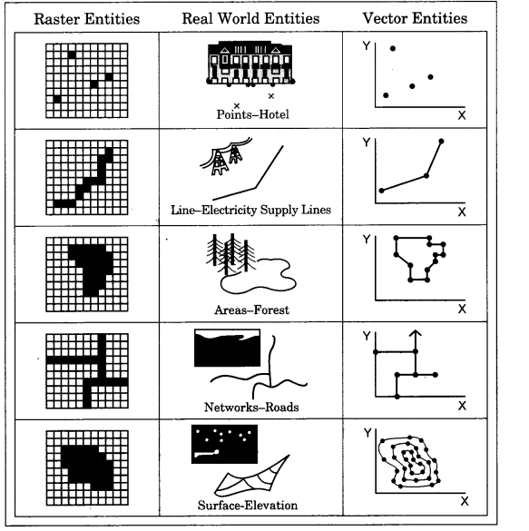
Fig. Representation of Spatial Entities in Raster and Vector Data Formats - The Raster file formats are most often used for the following activities:
For digital representations of aerial photographs, satellite images, scanned paper maps, etc.
When costs need to be kept down.
When the map does not require analysis of individual map features.
When ‘backdrop’ maps are required. - The Vector files are most often used for:
- Highly precise applications
When file sizes are important
When individual map features require analysis
When descriptive information must be stored - The following sequence of the activities are involved in GIS related work :
- Spatial data input
- Entering of the attribute data
- Data verification and editing
- Spatial and attribute data linkages
- Spatial analysis
- Raster Data Format: Raster data represents a graphic features a pattern of grid of squares.
- Vector Data Format: Vector data represents the object as a set of lines drawn between specific points.
- Scanners: The scanners are the devices for converting analogue data into digital grid- based images.
- Buffer Operation: A buffer of certain specified distance can be created along any. Point, line or area feature. It is useful in locating the areas population benefited or denied of the services polices such as hospitals, post office, etc.


0 Comments
Please Comment